CRATERS OF THE MOON NATIONAL MONUMENT
BEZIENSWAARDIGHEDEN / HIGHLIGHTS

Bezienswaardigheden / tips 2025:
1) Craters of the Moon National Monument: Een van de boeiendste bezienswaardigheden van Zuidoost-Idaho is het Craters of the Moon National Monument, 30 km ten zuidwesten van Arco, te bereiken via US Highway 20 en US Highways 26 en 93. Door de vele vulkaankraters, grotten en gestolde lavastromen lijkt dit gebied sterk op een maanlandschap, reden waarom de eerste astronauten in dit gebied werden getraind. Een lusvormige weg van 11 km lang, geopend van mei tot oktober voert langs de interessantste plekken. Omdat het park nogal afgelegen ligt krijgt het minder bezoekers dan de meeste parken. Het park krijgt ongeveer 271.000 duizend bezoekers per jaar. De weg naar het park toe is vrij rustig hou er rekening mee dat je buiten de bewoonde wereld bent en weinig tankstations tegen komt. Het is daarom ook raadzaam om met een volle tank te rijden. De entree is $ 20 per privé voertuig. Dit betreft iedereen in de auto. Voor motoren en hun passagiers is het $ 15. De entree voor voetgangers, fietsers bedraagt $ 10 per persoon. De entree voor kinderen onder de 15 jaar is gratis. Gooi je ontvangstbewijs niet weg want je kunt met dit ontvangstbewijs nog 7 dagen het park in. The America the Beautiful Pass is hier ook geldig.
2) Let op: Tussen Carey en Arco aan de Highway 20 (71 km) zijn er geen bezinestations en ook geen mogelijkheid om drank en proviand in te slaan.
3) Beste reistijd: De mooiste tijd om het monument te bezoeken is in het late voorjaar vanaf juni. Dan geven honderden verschillende wilde planten het zwarte landschap kleur. Al in oktober kan in dit gebied sneeuw vallen, maar omdat het overdag nog vaak behoorlijk warm wordt, blijft de witte deken op slechts enkele plaatsen liggen, wat door de sterke contrasten op de verder donkere ondergrond een fraai schouwspel oplevert. Het kraterlandschap ligt op een hoogte van 1800 m en de sterke wind is een permanent gegeven. 's Zomers kan het hier echter 40 graden worden, zodat een hoofdeksel en een zonnebrandmiddel geen overbodige luxe is. De sterke wind blaast kleine stukjes steen in het rond, zodat het ook verstandig is om een lange broek en een goede jas te dragen.
4) Wandelpaden: Voor bezoekers zijn door het onbegaanbare terrein enkele wegen en wandelpaden aangelegd. Om het kwetsbare ecologische evenwicht niet te verstoren is het beter om de wegen en paden niet te verlaten. Bij het Visitor Center direct aan de voet van Highway 20 begint een in totaal 11 km lang wandelpad dat voorzien is van zeven haltepunten met een bijhorende uitleg over het gebied. Zorg dat je goede wandelschoenen hebt, want het lavagesteente is scherp.
5) Kamperen: In de buurt van het Visitor Center bevindt zich een kampeerterrein met 51 plaatsen; reserveren is niet mogelijk, er zijn geen douches en geen aansluitingen voor campers.

Highlights / tips 2025:
1) Craters of the Moon National Monument: One of Southeast Idaho's most captivating attractions is the Craters of the Moon National Monument, located 19 miles southwest of Arco, accessed via US Highway 20 and US Highways 26 and 93. Due to the many volcanic craters, caves and solidified lava flows, this area strongly resembles a lunar landscape, which is why the first astronauts were trained in this area. An 7 miles (11 km) long loop road, open from May to October, takes you past the most interesting places. Because the park is quite remote, it gets fewer visitors than most parks. The park receives about 271,000 thousand visitors per year. The road to the park is fairly quiet, keep in mind that you are outside the civilized world and you will not come across many gas stations. It is therefore also recommended to drive with a full tank. The entrance fee is $ 20.00 per private vehicle. This concerns everyone in the car. For motorcycles and their passengers the entrance fee is $ 15.00. The entrance fee for pedestrians and cyclists is $ 10.00 per person. Admission for childeren under 15 is free. Do not throw your receipt away because you can enter the park with this receipt for another 7 days. The America the Beautiful Pass is also valid here.
2) Please note: Between Carey and Arco on Highway 20 (45 miles) there are no gas stations and also no possibility to stock up on drinks and provisions.
3) Best time to travel: The best time to visit the monument is in late spring, starting in June. Then hundreds of different wild plants give color to the black landscape. In October, snow can already fall in this area but because it often gets quite warm during the day, the white blanket remains in only a few places, which creates a beautiful spectacle due to the strong contrasts on the dark background. The crater landscape is located at an altitude of 5905 feet (1800 m) and the strong wind is a permanent feature. During the summer, it can be 104 fahrenheit (40 degrees) here, so a hat and sunscreen is not an unnecessary luxury. The strong wind blows small pieces of stone around, so it is also wise to wear long pants and a good jacket.
4) Trails: A number of roads and hiking trails have been laid out for visitors through the impassable terrain. In order not to disturb the fragile ecological balance, it is better not to leave the roads and paths. At the Visitor Center directly at the foot of Highway 20, a total of 7 miles (11 km) long hiking trail starts with seven stops with an explanation of the area. Make sure you have good walking shoes, because the lava rock is sharp.
5) Camping: Near the Visitor Center, there is a 51-place campsite; reservation is not possible, there are no showers and no connections for campers.
.jpg)
.jpg)
In 1923, toen men nog geen stap op de maan had gezet, bracht de geoloog Harold Stearns zijn indruk van deze enorme lavavelden op de volgende wijze onder woorden. Het lijkt hier op de oppervlakte van de maan, zoals ik die door mijn telescoop heb gezien. Niet verwonderlijk dat men het nationale monument bij de oprichting in 1924 deze naam heeft gegeven.
In 1923, when they had not set foot on the moon yet, the geologist Harold Stearns expressed his impression of these enormous lava fields in the following way. Here, it looks like the surface of the moon, as I saw it through my telescope. It is not surprising that the national monument was given this name when it was founded in 1924.
(1).jpg)
.jpg)
Ca. 15.000 jaar geleden begonnen de lavastromen uit een breuk in de Great Riff te stromen. Pas 2000 jaar geleden hielden de stromen op, nadat er in totaal acht uitbarstingen waren geweest.
Approx. 15,000 years ago, lava flows began flowing out of a rift in the Great Riff. It wasn't untill 2000 years ago that the flows stopped, after a total of eight eruptions.
(2).jpg)
.jpg)
De lavastromen ontsnapten via erupties in lange onderaardse spleten die dwars door de hoogvlakte de Snake River braken.
The lava flows escaped via eruptions in long subterranean fissures that broke the Snake River right through the plateau.
.jpg)
.jpg)
In totaal is een oppervlakte van zo'n 1000 km2 aangewezen als nationaal monument.
In total, an area of about 1000 km2 has been designated as a national monument.
.jpg)
.jpg)
Op 1986 meter ligt de Big Cinder Butte, de hoogste vulkaan in Craters of the Moon Monument.
Big Cinder Butte is the highest volcanic feature in Craters of the Moon Monument at 6515 ft.
.jpg)
(2).jpg)
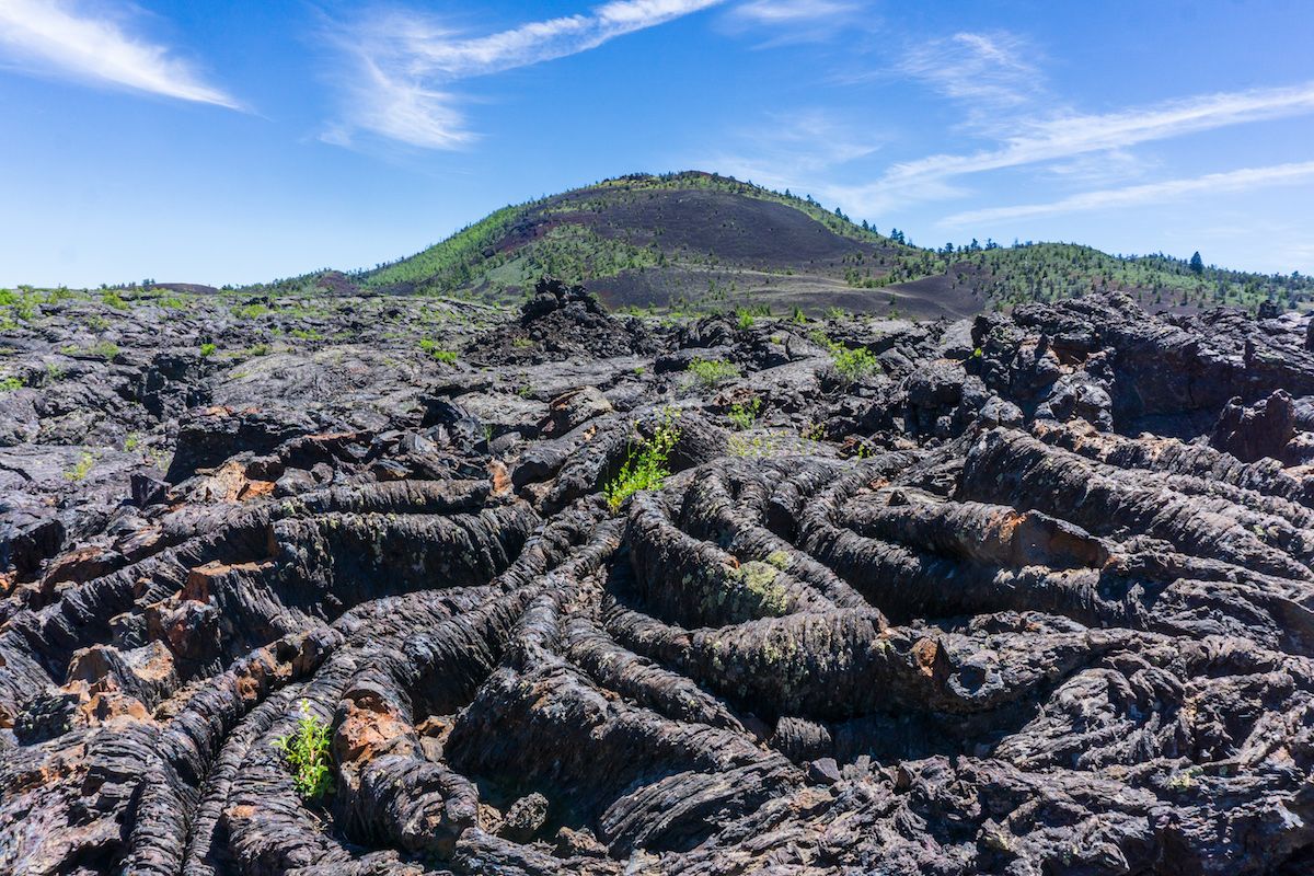
Ernaast zijn vlakten te zien met lava dat zo fijn is gepolijst dat het er vanuit de verte uitziet als zwart fluweel.
Next to it lies plains of lava so finely polished it looks like black velvet from afar.
.jpg)
.jpg)
Onder invloed van het zonlicht ondergaan de schijnbaar eentonige kleuren van het lavalandschap spectaculaire veranderingen. (zie film).
Under the influence of the sunlight, the apparently monotonous colors of the lava landscape undergo spectacular changes. (see film).
.jpg)
.jpg)
Met name 's ochtends en kort voor het invallen van de duisternis wordt duidelijk hoeveel kleuren de lavapatronen kunnen aannemen.
Especially in the morning and shortly before darkness falls, it becomes clear how many colors the lava patterns can take.
.jpg)
.jpg)
De lavagrotten hier zijn niet toegankelijk, deze mogen alleen bezichtigd worden met een ranger (hier op de film).
The lava caves are not accessible, they can only be visited with a ranger (here in the film).
(2).jpg)
.jpg)
De binnenkant van de lavagrotten.
The inside of the lava caves.
.jpg)
.jpg)
Grote delen van het gesteente is diep donkerbruin, maar ook strepen rood doorsnijden de askegels, een kleur die onstaat als de ijzerhoudende lava begint te oxideren. Ook de mossen en kortsmossen lichten in de morgen en avondzon op. (zie film).
Large parts of the rock is deep brown, but streaks of red also cut through the ash cones, a color that occurs when the ferruginous lava begins to oxidize. The mosses and lichens also light up in the morning and evening sun. (see film).
.jpg)
.jpg)
Bovendien heeft men rond deze tijd kans marmotten en het alleen in Noord-Amerika voorkomende muildierhert (mule deer) te zien, als ze uit hun schuilplaatsen komen om te eten. (zie film).
In addition, around this time, marmots and the North American mule deer are likely to be seen, when they come out of their hiding places to eat. (see film).
.jpg)
.jpg)
Een interessant fenomeen voor biologen zijn de zogenaamde kipukas. Dit zijn gebieden die door lava zijn ingesloten, zodat de oorspronkelijk vegetatie die in dit gebied bewaard is gebleven, vergeleken kan worden met de nieuwe begroeiing die is ontstaan op de lavavelden.
An interesting phenomenon for biologists are the so-called kipukas. These are areas enclosed by lava, so that the original vegetation preserved in this area can be compared with the new vegetation that has developed on the lava fields.
@MK